SPECIFICATIONS:
Total kilometers: 43 kilometers.
Access by vehicle: Pedra Moura de Aldemunde and Pedra da Arca de Cerqueda are accessible by private vehicle.
Access on foot:
- Marco da Anta: 310 meters from the road.
- Chan das Mudradas: 860 meters from the road.
- Fuso da Moura: 330 meters from the last wind turbine of the Fuso da Moura viewpoint.
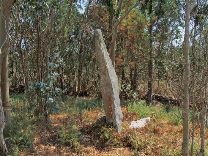
We begin the tour at the town hall of A Laracha, specifically visiting one of the few “pedrafitas” (menhirs) known in A Costa da Morte, the Marco da Anta, also called Pedra do Ghicho or Pedra do Carallo.
This curious name surely comes from its peculiar phallic shape.
Although it is not clear what its function may have been during prehistory, until recent times it was used as a marker indicating the boundary between two parishes.
To get there we must leave our vehicle on the road and take a mountain path for 900 meters until we reach the monument.
After the Marco we can resume the journey by car to go to the lands of the municipality of Carballo.
There, in the parish of Aldemunde, is the Pedra da Moura, in an almost idyllic setting, on a plot of meadow next to the road.
Its name evokes stories of Moors and Mouras, who for our elders were the mythical builders of dolmens and mámoas (tumuli).
In Aldemunde, it is said that the stones were transported by a moura from the Petón de Calvelo, while she was spinning on a spinning wheel and breastfeeding a child.
We return to the road and now head towards Coristanco until we reach the place of Bieite de Abaixo.
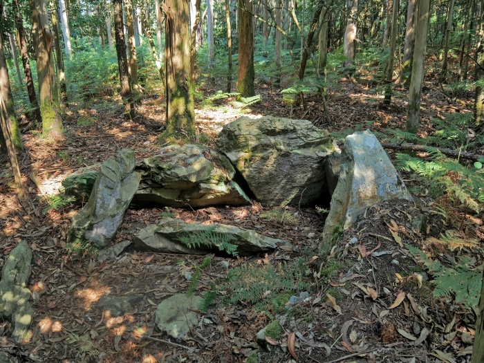
We leave the vehicle at the site and take a short walk of about 800 meters through the so-called Mount Figueiras to the dolmen of Chan das Embarradas.
The monument appears hidden in the middle of the forest, next to an old stone wall, which took advantage of part of the entrance corridor for its construction.
The megalith, which retains most of its structure, is made of huge schist stones and one of them is striking for having a darker hue than the others.
The next destination is the Pedra da Arca, in Cerqueda, in the municipality of Malpica, where the same legend of a moura who carried the stone slabs on her head while spinning with a spinning wheel and breastfeeding a baby reappears.
But what is most impressive about this anta is its monumentality, especially the roof stone that is estimated to reach 9 tons.
We leave Cerqueda and the new destination is located on Mount Asalo, on the border between the municipalities of Malpica and Ponteceso, in a wind farm that has one of the best panoramic views of all of A Costa da Morte.
Near the viewpoint of Fuso da Moura, there is a “little stone” with the same name and with a curious shape reminiscent of that of a spindle.
It is integrated into a megalithic necropolis and during prehistoric times it could have played the role of a signpost for burials.
Until not many years ago it was a tradition to take sick cattle there and for them to heal they had to first go around the stone several times and then, when coming down from the mountain, it was necessary to break a clay pot at a crossroads where there was a cross.


